
Paleozoic History of Nova Scotia A Time Trip to Africa (or South America)
Paleozoic History of Nova Scotia
A Time Trip to Africa (or South America)
Paul E. Schenk, Thomas Lane and Lyndon Jensen
INTRODUCTION
The place of southeastern Atlantic Canada, and specifically Nova Scotia, has always been a problem in the broad framework of Appalachian geology (figure 1). The hypothesis first proposed in the late 1960's by Professor Paul E. Schenk (PhD) of the Geology Department at Dalhousie University is:
- northern Nova Scotia is part of a micro-continent (Avaland) that was sandwiched during continental collision between North America and a part of Gondwana
- southern Nova Scotia (the Meguma Zone) evolved as a segment of a Gondwana continental margin, and clung to Avaland during the rifting that created the present North Atlantic
- and northern (Avalon) and southern (Meguma) Nova Scotia were built in quite different areas, and brought together fortuitously after large-scale displacements on the intervening Glooscap Fault.
Figure 1. Borderlands of the Appalachians
|
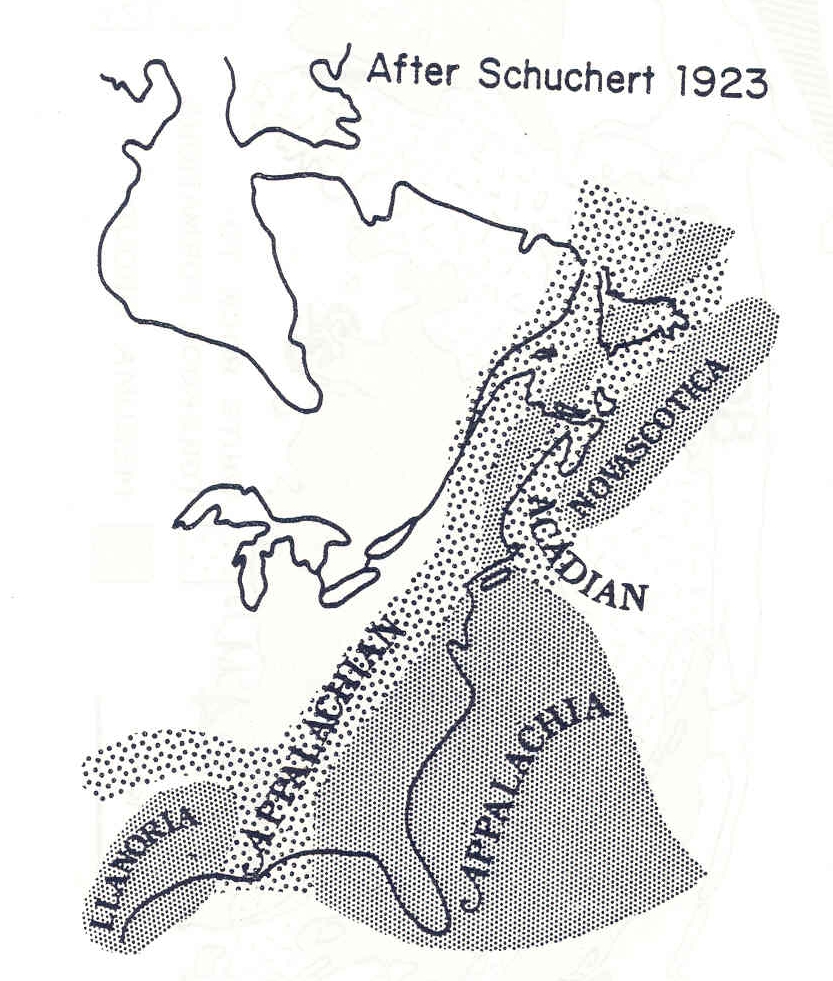
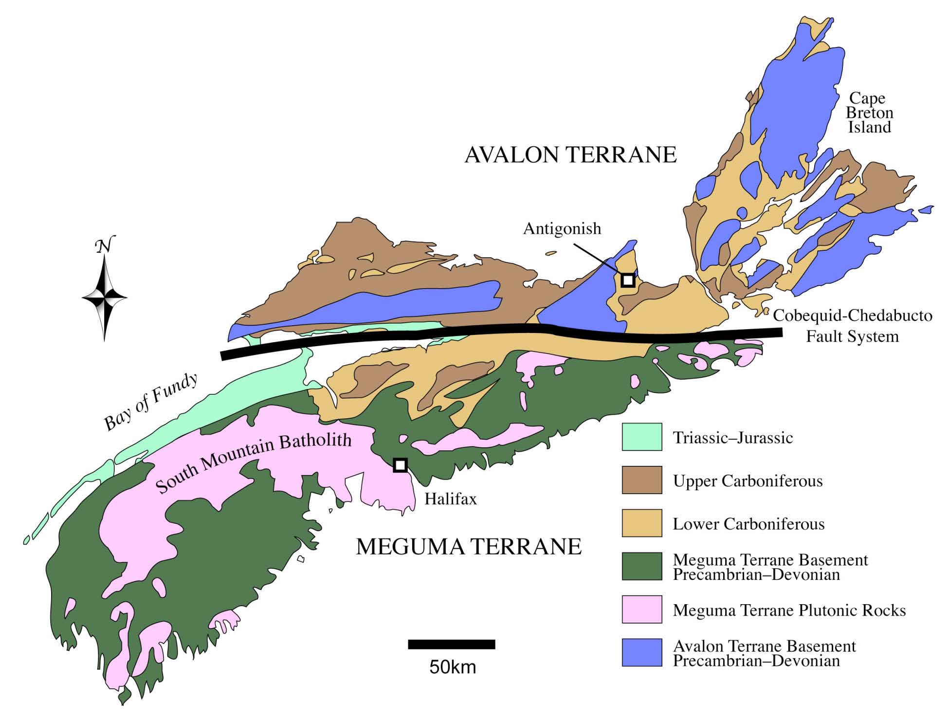
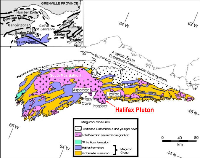
Figure 2. Generalized geologic map of Nova Scotia. Avalon and Meguma Terranes are juxtaposed along the Cobequid-Chedabucto Fault system. Locations of individual study areas are described in the text. After Keppie (2000). |
REGIONAL SETTING
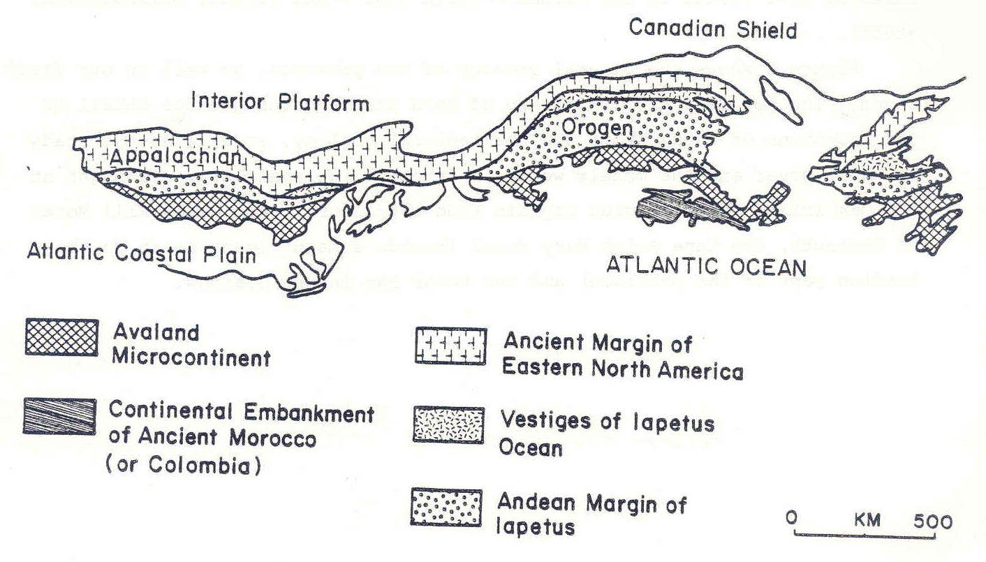
The Appalachian orogen of North America is divisible with some controversy into five tectonolithologic zones which range in age from Late Precambrian through the Early Paleozoic (figure 3). Four of these can be traced from Alabama to Newfoundland, and possibly even further into western Europe (Williams, 1978, a,b). These are:
- the eastern continental margin of North America
- the now-discontinuous remnants of an Early Paleozoic oceanic floor
- the western continental margin of the Avaland microcontinent with offshore welts
- and the Avaland microcontinent itself
The fifth zone, the Meguma, is an exception because it cannot be traced either to the northeast or to the southwest; consequently we have been forced to consider correlation toward the southeast. This is hazardous because sedimentologic, metamorphic, and structural changes are much more abrupt across the zone.
Fig. 3. The Appalachian Orogen, after Williams (1978a).
|
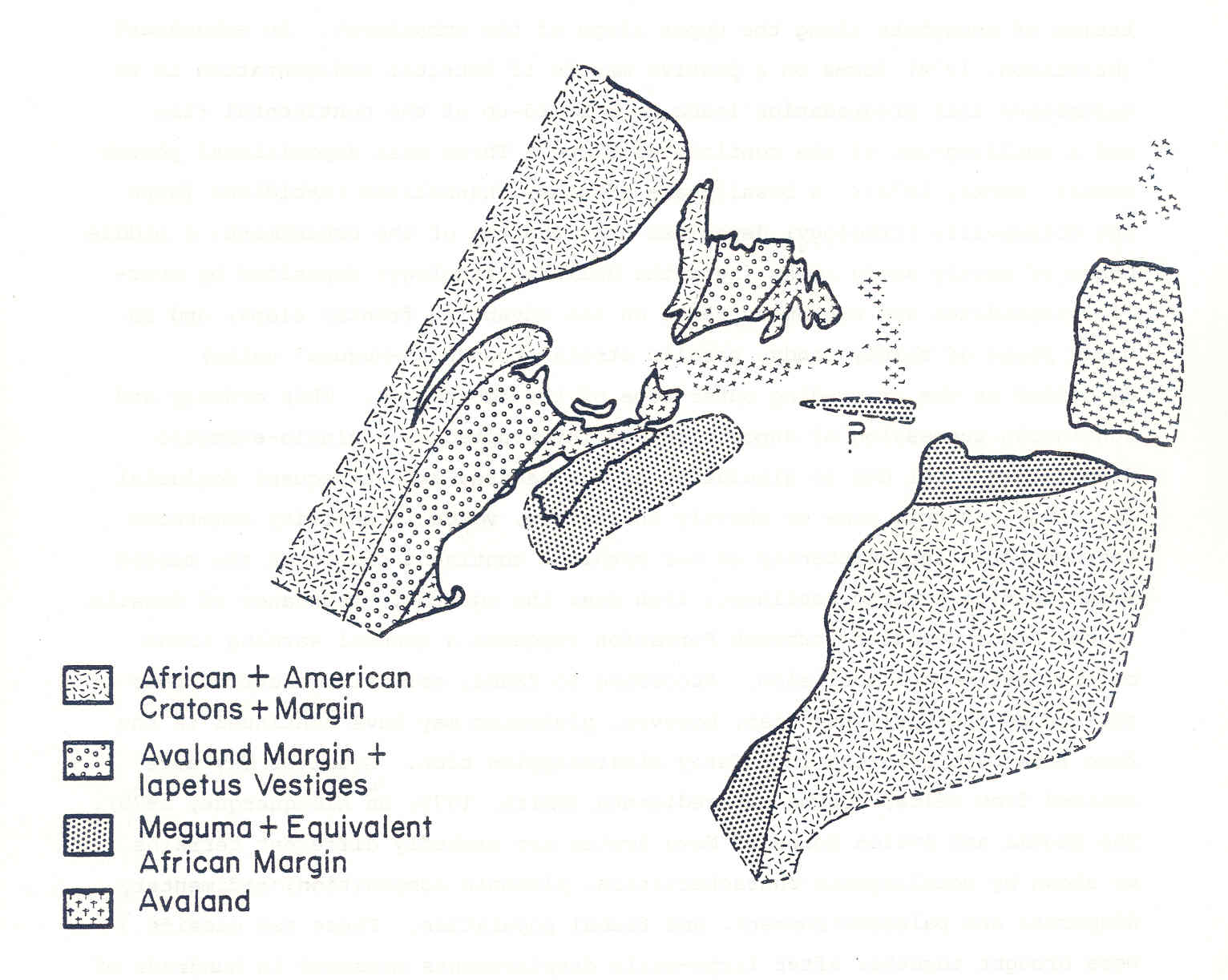
The Meguma Zone is a very large segment of the Appalachian orogen. It forms the bedrock of almost all of Nova Scotia south of the Glooscap Fault, as well as the foundation of both the offshore Scotian Shelf to the south (King and MacLean, 1976) and presumably the Bay of Fundy to the northwest. If recent work by Lefort and Haworth (in press) is correct, the Zone should also underlie part of the continental shelf both southeast of Cape Breton and also south of Newfoundland (figure 4). The thickness of the zone exceeds 14 km and if the strata were unfolded, the volume of rock would exceed 5 x 10⁶ km3 (equal to a block with the area of Ontario and Quebec, and a height of 2 km). Clearly the source area must have been several times larger because the absence of obvious unconformities within the Zone suggests that recycling of sediment was minimal.
Figure 4. Reconstruction after Lefort and Haworth (in press) showing geophysical corridor defined by fracture zones. Meguma Zone and possible equivalents in line pattern. Black area on Mediterranean shore of Morocco is the ultrabasic Sebtide region. Arrows give Cambro-Ordovician dispersal directions both of Meguma facies and Moroccan shelf-type siliciclastics.
|
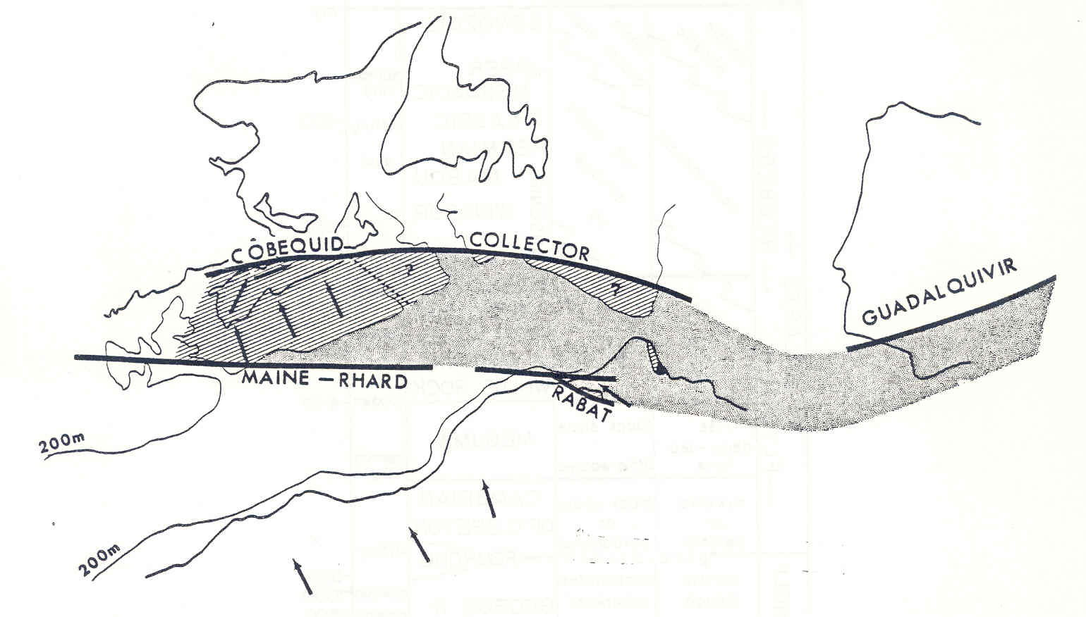
Figure 5 shows the general stratigraphic column of the Zone. Strata are conformable and apparently record continuous sedimentation from probable Cambrian through Early Devonian time - an interval of 200 Ma. Most of the Zone both in volume and geographic extent consists of the Meguma Group; younger rocks exposed only along the northwest are called here "Post-Meguma" strata.
Figure 5. Stratigraphic column of Meguma Zone, with tectonic cycles and plate events.
|
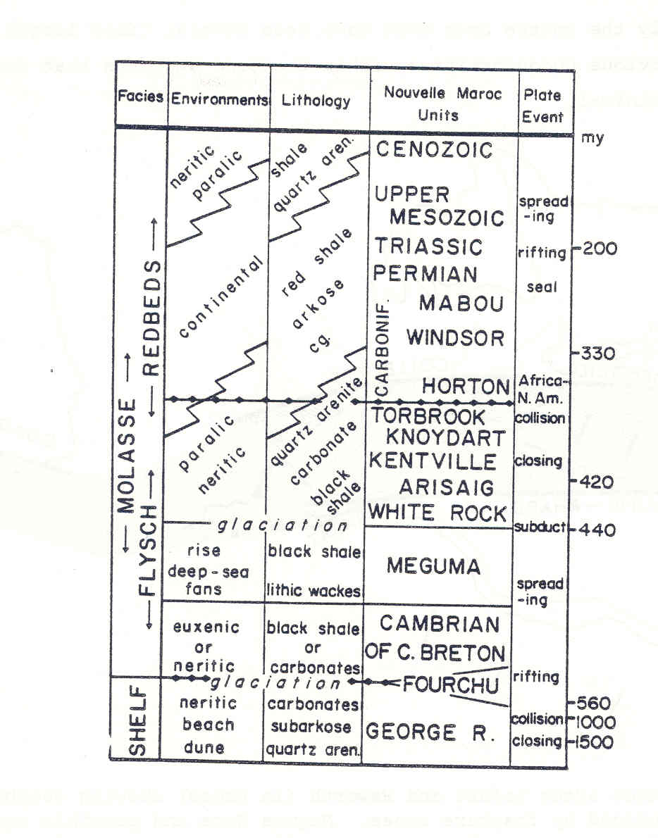
In general, the Meguma zone is envisioned as having originated as a segment of a continental embankment off a very large, passive, low relief, Precambrian continent to the present southeast that consisted of a deeply eroded, blue-quartz, granodioritic and metasedimentary terrain with an extensive continental shelf (figure 4). Upwelling may have caused precipitation of phosphate along the upper slope of the embankment. An embankment (Dickinson, 1974) forms on a passive margin if detrital sedimentation is so voluminous that progradation leads to a build-up of the continental rise and a building-out of the continental slope. Three main depositional phases result (Burke, 1972): a basal phase of sandy channelized turbidites (here the Goldenville lithology) deposited near the toe of the embankment; a middle phase of mainly shaly rocks (here the Halifax lithology) deposited by overflow turbidites and bottom currents on the advancing frontal slope; and an upper phase of mainly sandy, paralic strata (the "post-Meguma" units) deposited on the prograding outer edge of the embankment. This orderly and continuous succession of deposition was interrupted by a glacio-eustatic drop in sea level due to glaciation of the Sahara, and subsequent deglacial flooding. At this time or shortly thereafter, volcanic activity commenced and continued intermittently as our mythical continent closed on the merged North America/Avaland continent, then near the equator. Abundance of fossils in the Lower Devonian Torbrook Formation suggests a general warming trend before continental collision. According to fauna, collision occurred near the end of the Early Devonian; however, plutonism may have continued in the Zone from Late Silurian into Early Mississippian time. Granites may have evolved from melted Meguma metasediments (Smith, 1979; de Albuquerque, 1979). The Meguma and Avalon Zones of Nova Scotia are markedly different terrains, as shown by metallogenic characteristics, plutonic composition, sedimentary dispersal and paleoenvironment, and faunal population. These two massifs were brought together after large-scale displacements measured in hundreds of km along the Glooscap Fault.
Movement along the fault may have been mainly strike-slip (dextral) but thrusting may also have been very important. In this scenario, the Meguma Zone acts as a portion of the continental margin of a very large exotic continent which collided with North America in Early Devonian time. Ragged rifting during the Mesozoic ripped a portion of this margin from the other continent to leave the Meguma Zone, clinging against North America. If so, we might expect to find the remaining margin of this mythical continent, even with a segment missing, still attached to a relatively undeformed Early Paleozoic continental shelf and Precambrian Shield (figure 6).
Figure 6. The Meguma Zone as a missing segment of the African margin..
|
Lower Paleozoic Strata of the Meguma Zone
Meguma Group
In general, the unit is at least 10 km thick, consisting basically of alternating layers of quartz metawacke and black slate. Conventional thought on stratigraphic order is essentially based on the ratio of sand to shale. The Group is divided into the sandier, supposedly basal Goldenville Formation, and the shaly, supposedly upper Halifax Formation (figure 7). Fauna thus far recovered from all parts of the Meguma Group are all only of Tremadocian age.
Figure 7. Geologic map of the Meguma Group and its intruding granitic plutons
|
Schenk (1970 and unpublished data) undertook a sedimentologic study of the entire Meguma area, and on this basis outlined the following characteristics of the sediments:
- The Goldenville Formation comprises sandy flysch; the Halifax Formation is composed of several facies of dominantly fine-grained sediments, of which shaly flysch is probably predominant. The shaly flysch is distinguished from other facies of the Halifax Formation by the preponderance of beds displaying the Bouma sequence of structures, mainly CDE and BCDES
- Graded bedding is generally weakly developed in the thick sandstone beds that make up much of the Goldenville Formation; however, a few of the thick beds display excellent, continuous grading. Normally, grading is restricted to the upper few centimetres of sandstone beds; the main part of the bed typically has a uniform distribution of grain sizes, and generally either is structureless or has diffuse parallel lamination. This lamination is distinct from the sharply-defined, planar lamination that occurs towards the tops of many beds (i.e., the Bouma B division). The Bouma C, ripple-lamination division is widely developed in parts of the Halifax Formation, but is generally restricted in development or missing altogether in the upper portions of thick sandstone bedsj
- Lenses and layers of conglomeratic material occur in some beds mainly composed of sandstone, particularly in the lower parts of the beds. Beds made up entirely of conglomerate or conglomeratic sandstone are rarel
- Intraformational clasts (mudstone-siltstone rip-ups) are components of many of the Goldenville beds. They occur preferentially in thick beds, and probably were derived from the undercutting of channel walls
- Groove markings are abundant on the undersurfaces of beds in the Goldenville Formation, but are relatively, uncommon in the Halifax Formation]
- Flutes are especially abundant in the transitional zone between Goldenville and Halifax lithosomes (where sand/shale ratio is close to unity), and are common but less abundant in the Goldenville sandy flysch
- Channels that eroded up to three metres into the pre-existing layers are evident at many outcrops. Larger channels, although present, are generally too large for their whole shape to be viewed in outcrop
- Load structures are very abundant in the Goldenville Formation. Many are associated with asymmetrical flame structures formed by sand foundering into fine-grained material during the deposition of the bed. Load-balls (pseudonodules) are locally well-developed in the shaly flysch of the Halifax Formation}
- Trace fossils are present at many outcrops, but generally not in great numbers. Vertical shafts, some twinned (presumably U-tubes), are the most visible biogenic structures in the Halifax Formation, and the trails of organisms are conspicuous at the base of some sandstone beds in the Goldenville Formation. Several Nereites-type forms have been recovered from the Goldenville. Sand volcanoes at upper bedding surfaces and vertical pillar structures within sandstone beds probably represent both organic and inorganic dewatering structures.
In the field, Halifax lithologies are intercalated with Goldenville lithologies in scales ranging from ten cm to hundreds of metres. According to the facies classification of Walker and Mutti (1973), sand layers of the Halifax correspond to Facies D ("classical" distal turbidites of Walker, 1967) and G (pelagic and hemi-pelagic muds and silts) with minor amounts of C (Bouma's AE, proximal turbidites). The latter two facies appear identical to overbank turbidites and contourites of the present Laurentian Fan (Stow, 1977; 1979). Sands of the Goldenville lithologies are mainly of Facies B2 (massive sandstones without dish structures) and Facies C with minor A2 (organized conglomerates), A4 (organized pebbly sandstone), and BI (massive sandstones with dish structures). Goldenville lithologies represent channel deposition in the mid-fan area of submarine fan systems. In broad aspect, the Halifax and Goldenville lithologies are pictured as parts of a co4iplex, inter-fingering, at least partly coeval complex.
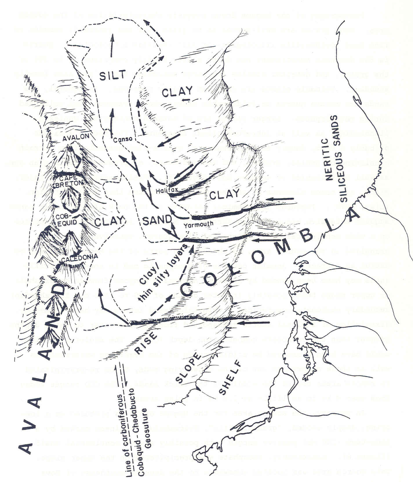
The dispersal pattern appears constant throughout the time in which the Group was deposited. The paleocurrents turn approximately 90 degrees from north in the southwest to east in the eastern part of the province (figures 4, S). Local variations to this trend are consistently toward the northwest. The paleocurrent trend appears to "contour" sedimentologic,scalar properties - i.e. paleocurrents trend along, not across contours of such properties as grain size, layer thickness, percent lithic clasts, etc. Stated another way, the broad paleocurrent-trend (i.e. the right hook) is almost at right angles to local variations from the trend, as well as dispersal direction inferred from lateral variations in the scalar properties. The dispersal pattern seems very similar to recent deposition in the western North Atlantic (Horn et al., 1971; Elmore et al., 1979).
In the Hatteras abyssal plain, channelized turbidites issuing from canyons in the continental slope, hook 900 to the right because of deflection of turbidity currents by the Bermuda topographic high (figure 9). Thus the general trend is parallel to the adjacent slope of North America. The intervening continental rise is swept by contour-following currents of the Western Boundary Undercurrent that transport fine-grained sediment to the south. Both currents parallel each other as well as the adjacent continental slope which is incised by many contributory canyons. Conceivably the continental rise is prograding over the abyssal plain. In a similar manner, dispersal patterns in the Meguma Group are seen as trending more or less parallel to its ancient continental margin. Parts of the upper Group may indeed be deposits of the continental rise or even slope.
Figure 8. Provenance and dispersal pattern of the Meguma Group, and presumed source-area
|
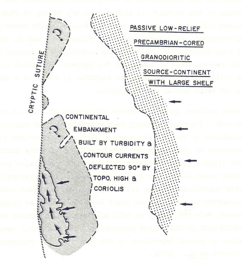
Figure 9. Possible Cambro-Ordovician setting of Meguma Group building between Colombia and Avaland. If figure is rotated 1800, the area of Megumadeposition becomes the present Hatteras abyssal fan, Colombia becomes the eastern United States, and Avaland becomes the topographic high of the Bermuda Rise.
|
Petrography of the Meguma Group suggests characteristics of the source area. Sand grains are well-sorted as to grain size and generally consist of fine sand (Goldenville lithologies) or silt (Halifax lithologies). Quartz is the dominant constituent but fresh albite locally comprises up to 30% of the grains, and detrital biotite and large muscovite flakes are also locally abundant. Volcanic clasts are rare but locally numerous. In general, the sands are mature quartz to feldspathic wackes whose framework has collapsed during metamorphism. Larger clasts are of metasedimentary and gneissic lithologies, as well as intraformational fragments. The source area was probably a vast, deeply eroded, cratonic, quartz-rich granodioritic terrain consisting of gneiss, granite, and metasediments, of presumed Precambrian age, as well as volcanics of unknown age (figure 8). Preliminary study of major, minor, and trace elements of the Meguma substantiates this interpretation (Liew, 1979). Textural and chemical maturity of the bulk of the Meguma sands suggest extensive winnowing and sorting by sluggish streams and/or processes on a wide continental shelf. Detrital blue quartz, conceivably from a granulite in the source area, is abundant in parts of the Meguma, and may be useful as a tracer. Angular pebbles of phosphatic mud in some Goldenville sands may have been eroded by headward migrating canyons from an outer shelf or upper slope belt, possibly in water depths of 200 to 1500 m. The abundant secondary carbonate concretions within thick sand layers may have formed by dissolution of skeletal debris transported from shallow water to water depths greater than the carbonate compensation depth (CCD). The skeletal debris would have been dissolved by acidic waters of the overlying watermass, as well as those compressed out of the underlying muds, to be re-precipitated in remote areas toward the middle of the thick sands. The CCD ranges today from near 4 km to as little as 0.4 km in polar areas.
In summary, the source area for the Meguma Group is pictured as a lowlying, deeply eroded, "granodioritic", Precambrian continent marked by a long-term (200 Ma) passive margin with possibly a wide continental shelf (figure 8). Conceivably, phosphate was precipitated on the upper slope. This source area was located somewhere to the present southeast of Nova Scotia. Very interestingly, this conclusion is not new. Schuchert (1923) pictured a borderland that he called Nova Scotica southeast of Atlantic Canada (figure 1). Douglas et al. (1938) agreed that the source area for the Meguma was to the present southeast (and even specified the outer edge of the present continental shelf). Moreover, they state that the chemical and mineralogical composition of these sediments suggest derivation from a granitic or gneissic terrain. They argued that evidence of traction currents indicated a shallow-water setting (since proven not to be a criterion), and interestingly that size-graded laminae were glacial varves.
Figure 10. Late Ordovician glaciation of northwestern Africa. The Meguma Zone is pictured as African, abyssal, and polar
|
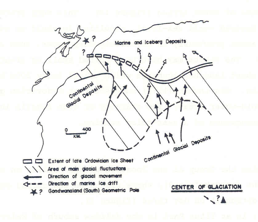
The uppermost part of the Meguma Group in the northwest rim of the Meguma Zone (figure 2) contains an important unit to discriminate possible source areas. This is a pebble to boulder mudstone which is traceable discontinuously over a distance of 185 km. It thickens from less than a metre in the west to 35 m in the east. The immediately underlying and overlying sediment is a distinctive, finely laminated slate which is intercalated with rippled slates of the Halifax below and the White Rock Formation above. The matrix of the diamictite is usually massive, but where laminated, pebble dents are seen. Clast lithologies are mainly of a finely laminated to micro-cross-laminated siltstone that is unknown elsewhere in the province; other clast-types are chert, vein quartz, metaquartzite, felsite, and dark grey argillite. Clast shape is angular to subround but some show polish, striations, and grooves on facets (Schenk, 1972). Schenk (1972) and Schenk and Lane (in press) argued that the unit is a glacio-marine tillite (drift-ice deposit) related to the Ashgillian glaciation of North Africa (figure 10). This very profound glacial episode must have lowered world sea-level, resulting in shelf or even paralic environments over areas previously in relatively deep water, such as upper slope environments. The clasts may have been rafted small or great distances; the Greenland ice sheet launches icebergs which travel today 2000 km to areas south of Nova Scotia. Skevington (1978) suggests that Ordovician graptolites may have shunned cold-water areas. The scarcity of such fossils in the Meguma may be a consequence of a near-polar setting.