
")
The ocean covers over 70 per cent of the Earth’s surface, yet we understand little about its geological structures. Less than 10 per cent of the ocean floor has been adequately mapped — leaving scientists with unanswered questions about the Earth’s processes and history.
The Benthic Ecosystem Mapping & Engagement (BEcoME) project is an OFI-supported research project led by Dalhousie and Memorial University. It aims to better understand the role of benthic habitats amidst the changing ocean climate.
To understand these ecosystems on the sea floor, scientists first need to know what the ecosystems look like by using innovative technologies to create maps of their physical features.
Mapping the ocean floor in Galápagos
To better understand the waters of a unique area in the Pacific Ocean, a team of OFI-supported marine scientists embarked on a research expedition to the Galápagos called Project Zombie. Throughout the five-week voyage, also supported by the Schmidt Ocean Institute (SOI), the team set out to collect data supporting the BEcoME project with new seafloor mapping technologies.
Aboard the Falkor (too) research vessel were 24 scientists from around the world, led by Chief Scientist Dr. John Jamieson from Memorial University and including BEcoME project co-lead Dr. Craig Brown from Dalhousie and PhD candidates Caroline Gini (MUN) and Jake Tan (Dalhousie).
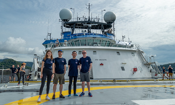 Left to right: Caroline Gini, John Jamieson, Jake Tan, Craig Brown, the OFI-affiliated participants on the expedition. (John Jamieson photo)
The team was sent to test the capabilities of new imaging technology called Interferometric Synthetic Aperture Sonar (SAS) developed by Newfoundland-based Kraken Robotics. This seafloor mapping technology can generate both high-resolution acoustic images and bathymetric maps of the ocean floor. The technology is used in other offshore applications such as defense and offshore energy but had not previously been tested for its scientific applications.
“The OFI BEcoME project is pushing the boundaries of research by exploring and testing the application of some new mapping technologies. This SOI cruise was an exciting opportunity to install the latest mapping systems on a state-of-the-art deep-water submersible, and really put them through their paces in a deep water environment”, says Dr. Craig. “These areas had never been mapped before, and in addition to testing the technologies, the data led to the discovery of new hydrothermal vent systems”.
Underwater discoveries
“The success and efficiency of the high-resolution mapping and imaging for exploration, discovery and classification of the seafloor, as demonstrated by this project, is validation of importance of developing and testing new technology for understanding the benthic environment”, says Dr. Jamieson.
 With the ease and precision of the InSAS technology, Dr. Jamieson and his crew returned to shore with many new and amazing findings.
The research team explored three hydrothermal vent fields north of the Galápagos Islands, including one field that was newly discovered on the expedition using the high-resolution mapping technology. The team promptly named this hydrothermal vent “Tortugas,” in reference to the famous turtles that are common in the waters around the islands.
Hydrothermal vents are found in association with submarine volcanoes along oceanic tectonic plate boundaries. Heat from magma beneath the seafloor causes seawater to circulate through the crust and form hot springs at the seafloor, where specially adapted underwater life can thrive. The vents are also known for being rich in valuable metals, and the expedition scientists are working to understand the formation and resource potential of these mineral deposits as well as the environmental risks associated with their potential exploitation.
During the expedition, the researchers further identified a pacific white skate nursery, only one of two documented globally, and 15 species of sea floor animals that were previously unknown to the area, some of which may be entirely new to science.
Mapping deep-water coral reefs in 3D
Dr. Katleen Robert from Memorial University’s Marine Institute, and the other BEcoME project co-lead, led a separate expedition on the Falkor (too) in the Galápagos ahead of Dr. Jamieson’s cruise also collecting data for the BEcoME project.
Dr. Robert and her team addressed another of the BEcoME project’s goals — mapping deep-water coral habitats in 3D.
The Galápagos Islands contain many deep-water cliff-dwelling coral reefs virtually unaffected by human impacts, and living under different environmental conditions. Expanding our understanding of cold-water corals across the globe is vital to predict how deep-water coral reefs are likely to change in the near future. Dr. Robert and her team utilised cutting edge Voyis Insight Micro laser scanner to create ultra-high resolution point-cloud reconstructions of these reefs—an achievement previously difficult to accomplish due to inadequate technologies.
SuBastian, the cutting edge remotely-operated vehicle (ROV) used on the expedition, is specifically designed for the deep sea. It can reach depths of up to four-thousand-five-hundred meters and was specifically outfitted with the laser system to collect data on reefs discovered at roughly 350 metres. This dataset will enable investigation of fine-scale relationships between habitat complexity and the organisms that inhabit these areas. Dr. Katleen Robert’s expedition retuned with great success, having discovered two deep-sea reefs. The reefs were booming with life, and the larger of the two spanned eight-hundred meters in length.
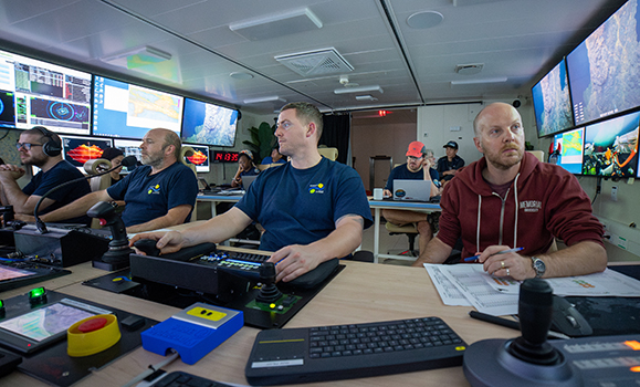 Dr. John Jamieson, centre, working in the ROV control room. (Schmidt Ocean Institute photo)
“We are thrilled our mapping data are able to improve our understanding of reef ecosystems in the Galápagos” says Dr. Robert. “The interdisciplinary science team is excited that the data collected during this expedition will contribute to growing knowledge on the Galápagos National Marine Reserve and contribute to the management of the Eastern Tropical Pacific Marine Corridor.”
The BEcoME project is continuing to work towards improving the collective understanding of the ocean floor via mapping to help facilitate future sustainable ocean stewardship.
This article was originally published by the Ocean Frontier Institute.
Now read
With support from the Canada First Research Excellence Fund, Dalhousie is leading an ocean-first approach to tackle climate change and equipping Canada with the knowledge, innovations, and opportunities to secure a positive climate future. Our Transforming Climate Action series on Dal News spotlights some of the incredible work our researchers are doing in this area: