
")
Almost 200 kilometres off the coast of Nova Scotia sits a slender, crescent-shaped spit of land known for mythic wild horses that roam its dunes, seals that dot its low-slung shores and hundreds of shipwrecks still populating its watery depths.
For centuries, Sable Island has also been home to rare seabirds, plants and insects, despite its vulnerable location in the path of powerful nor’easters and hurricanes that routinely track up the Atlantic coast of North America.
New research, however, suggests that a vital part of the ecosystem that sustains the fabled island's forms of life is being compromised.
The Dal-led team assessed the quantity and quality of the island's fresh groundwater, which flows into freshwater ponds and supports the wild horses, plants and birds. Members collected groundwater monitoring data from 2019 to 2022 to compare the water's salinity and distribution to measurements taken in the 1970s.
They found fresh groundwater loss tied to decades of dune erosion, seasonal waves, storms and hurricanes. During storms, seawater floods the beaches, leaches into the ground and salinizes fresh beach groundwater. When storms repeatedly batter the island, floodwaters can erode dunes and cause groundwater salinization to incrementally shift landward and lead to long-term freshwater loss.
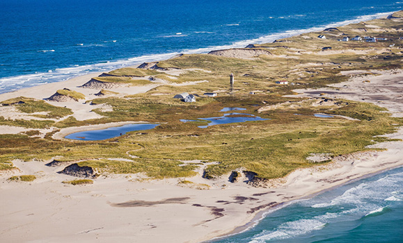
Aerial photo of ponds amongst the dynamic dune landscape.
"Worldwide there are few uninhabited islands with historical monitoring data, like what is available for Sable Island, so the opportunity to assess how long-term changes in fresh groundwater are coupled with the shape and extent of island dunes is very unique," says Julia Cantelon, a PhD candidate in Dalhousie's Coastal Hydrology Lab who led the study.
"Sable Island is famously known for its shifting sand dunes, and our results show that over time, large events that drive rapid changes, like flooding and erosion, can re-shape the island topography and impact the fresh groundwater resources."
Cantelon's research suggests that while saltwater can be flushed out by rainfall because groundwater flows slowly, there is often not enough time for the freshwater to recover before it is flooded again by another storm.
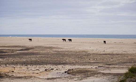
Horses on the flood prone south beach.
Erosion the culprit
Co-author Barret Kurylyk, the Canada Research Chair in Coastal Hydrology at Dalhousie, explains that small islands are underlain by a zone of fresh groundwater that is known as a 'freshwater lens,' given its shape. On Sable Island, groundwater in the freshwater lens flows into freshwater ponds that sustain the unique, rich ecosystem.
The concern is that the steady erosion of dunes on the island has reduced the volume of that vital freshwater lens.
Dr. Kurylyk says the results have implications for freshwater security on more populous small islands around the world that rely on groundwater for freshwater supply that is increasingly threatened by salinization.
"While the shallow groundwater and ponds may not be severely impacted, the results are concerning for populated barrier islands that are host to people reliant on groundwater for their drinking water supply."
Coastal seawater flooding devastates thousands of kilometers of shoreline annually, and coastal fresh groundwater resources are extremely vulnerable to contamination from these flood events, the study states. Because of that, the authors say there is an urgent need for more long-term and large-scale coastal groundwater monitoring and mapping programs to understand saltwater incursion processes and inform appropriate management action.
 The Dal researchers' work adds to that knowledge base as previous studies have focused on the impacts of humans, sea-level rise or coastal flooding on the freshwater lens, whereas this study demonstrates that erosion is an often-overlooked driver of freshwater loss.
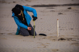
Shown left: Julia Cantelon maintaining instruments on the south beach to flooding impacts.
"Hydrological research has been ongoing on Sable Island since the 1970s. However, this dynamic island continues to evolve and the work by Dalhousie researchers has really advanced Parks Canada’s understanding of the freshwater dynamics of the island," says Dan Kehler, the island's ecologist with Parks Canada.
"This work continues to highlight the pivotal role that hydrology plays for this offshore sand island, and how coastal processes like storms and waves have surprising effects on the island as a whole."
Parks Canada has been stewarding Sable Island since the National Park Reserve was created in 2013, working with partners and the Mi’kmaq of Nova Scotia, to ensure the protection and preservation of this special island.
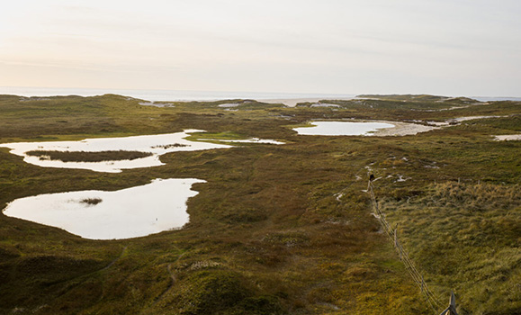
Ponds on Sable Island.