
 satellite's science instrument payload sits in a clean room at NASA's Jet Propulsion Laboratory during assembly (NASA/JPL-Caltech photo).")
When Hurricane Fiona hit the East Coast of Canada, many in coastal communities had one pressing concern on their minds — how high will the ocean surge? The answer to the question would make the difference of whether their evacuation was necessary or if their homes made it through the storm.
Two Dalhousie-based researchers aim to deliver a new understanding of the waters that surround us with help from data to be transmitted from a satellite launched this morning from Vandenberg Space Force Base in California. The Surface Water and Ocean Topography (SWOT) satellite mission was developed by NASA and the French space agency, Centre National d’Études Spatiales (CNES), with contributions from the Canadian and UK Space Agencies.
“Until now, we could only measure sea surface height on large ocean-basin scales, using conventional altimeter satellites. They use a very narrow downward-looking radar beam following the satellite track. But that can only resolve coarse ocean surface features. It’s not nearly enough to tell us the topography of finer scale eddies and ocean fronts,” said Dr. William Perrie, an adjunct professor at Dalhousie who is also a senior research scientist at Canada’s Department of Fisheries and Oceans.
Zooming in on surface water
SWOT will be the first satellite mission to observe nearly all the planet’s surface water, measuring water levels in lakes, rivers, reservoirs, and the ocean, giving scientists the ability to track the movement of water around the world. The SWOT satellite will provide a detailed view of a swath of 120 kilometers along its trajectory, providing a high-resolution picture of ocean circulation and currents in the open ocean and coastal areas.
Dr. Perrie and his Dalhousie SWOT project partner, Dr. Guoqiang Liu, will focus primarily on the ocean, harnessing this new data to improve computer models currently used to predict its movements and how these movements impact coastal communities, weather, climate, and ecosystems.
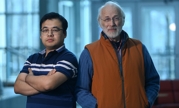
Dr. Guoqiang Liu and Dr. William Perrie will harness the new data to improve computer models currently used to predict ocean movements (Danny Abriel photo).
Sharing data, better decisions
“We will share the data we collect with Environment and Climate Change Canada and colleagues in other research centres to improve their models. The most important part of SWOT is that it can measure water surface height, which is very important for understanding a wide range of phenomena, from the topography of lakes and rivers, to coastal flooding and storm surge, to ocean currents and circulation. The data will benefit all parts of society and will be particularity significant for people living along coastlines,” said Dr. Liu.
Until SWOT, getting a definitive understanding of how sea level height has changed over time has been difficult using observations from space- and Earth-based instruments. New insights from SWOT into coastal sea level will eventually lead to improved accuracy in computer models necessary for understanding climate change, sea level rise projections, coastal flood forecasting and a plethora of other environment and climate issues.
For example, Dr. Perrie will use the data to help guide decisions to protect the endangered right whales that migrate to the Bay of Fundy, Gulf of Saint Lawrence and other waters off Canada’s East Coast.
“SWOT will allow us to better monitor the Gaspé Current and therefore we think it will help us better estimate where the whales might congregate,” he says. “And this is important because if the whales are there, then Canada’s Department of Fisheries and Oceans will want to closely monitor these waters and possibly close the area to fisheries and shipping to stop whales from being killed by ship strikes or fish net entanglements.”
He says right whales are just one species that could benefit, noting that better understanding of physical oceanography will provide the information we need to better manage our engagement in all ocean ecosystems.
Beyond SWOT
He’s also hopeful that that SWOT mission will help with our understanding of the impacts and future of climate change but cautions that answers won’t come quickly.
“Climate is a long-term process. You need to build up data for years and decades before you can detect trends. But better data like this will lead to a better understanding of weather and climate, both seasonal and longer-term prediction. It will be a step-by-step process,” he says.
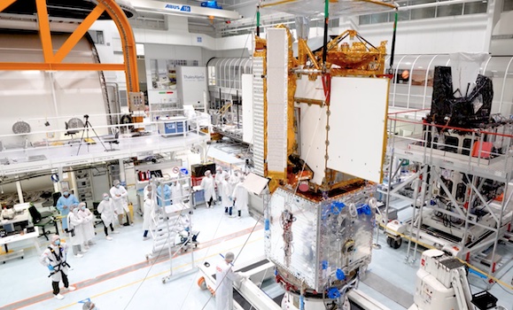 Engineers integrate separate parts of the SWOT satellite into one in a Thales Alenia Space clean room facility in Cannes, France (Thales Alenia Space photo).
SWOT will orbit around the planet and repeat its imaging every 21 days over its three-year mission, providing a new picture of how our planet’s water changes over time. Dr. Perrie says scientists are already beginning to make plans for subsequent missions.
“Satellites have limited lifetimes, but they take years to build. So, we are already beginning to think about how to enhance SWOT and move to the next levels, to come after.”