

News
» Go to news mainA Tale of Two Pod Deployments

A novel benthic pod, supported by the Marine Environmental Observation, Prediction and Response (MEOPAR) Network, was successfully deployed in the bottom waters of Bedford Basin on March 7, 2019 by the Coastal Environmental Observation Technology and Research (CEOTR) Group. But this was not the first trip to the depths of Bedford Basin for this pod, which spent 3 months at 60 meters last fall.
The Bedford Basin Pod is made up of a suite of sensors, which are affectionately referred to as “pod students” by Maddie Evans, the main Field Technician dedicated to this project. The sensors are all unique in their configuration methods and some are easier to integrate into the data logger, the SATLANTIC STOR-X, than others. Some of these sensors have been A+ students, collecting data throughout the entire deployment, while other instruments have struggled and stopped collecting data a few weeks into the three-month deployment. There is never a dull moment with the design, development, and data collected from the pod and new challenges constantly come up resulting in new and improved designs with each subsequent pod deployment.
The first version of the Bedford Basin Pod was deployed on August 20, 2018, primarily as a test bed for an RBR Optical Dissolved Oxygen (ODO) sensor, and secondly as a way to measure Bedford Basin bottom water conditions at a higher resolution. The first deployment of the pod resulted in a collection of conductivity, temperature, depth, nitrate, CO2, dissolved oxygen, turbidity, and chlorophyll florescence data. All of the sensors on the pod were configured to collect one minute of data every hour, for 24 hours per day, for the entirety of the deployment time. The pod was deployed at 41˚41’58” N, 63˚38’40” W, the same approximate location where Dalhousie University and Bedford Institute of Oceanography (BIO) collect weekly time series data, such as discrete water samples (such as nutrients, chlorophyll, etc.) and in situ bio-optical profiles of the water column. After three months on the bottom, the pod was recovered on December 7, 2018. Using the weekly Bedford Basin Time Series (BBTS) data collected alongside this deployment, data collected by the sensors on the Bedford Basin Pod were validated against this data.
To the astonishment of the entire CEOTR Bedford Basin sampling team, the Bedford Basin Pod was able to capture an event that has alluded scientists studying Bedford Basin for decades: an intrusion event. Scientists studying Bedford Basin have been aware of these intrusion events, however the dynamics of how these events take place, and in particular how fast these events are happening, are not well known.
Bedford Basin is a deep (~71m) fjord with a sill depth of ~20m at the entrance to the basin, and separated from the adjacent Scotian Shelf by a 10km long channel. It is stratified by temperature seasonally, and salinity almost year-round, which results in low-oxygen bottom waters that are replenished periodically by wind-induced mixing or lateral intrusion events. Intrusion events result from a build-up of coastal sea level, bringing dense offshore shelf water with higher oxygen levels over the sill in the narrows and into the deep waters of Bedford Basin. These events are typically characterized by an abrupt change in temperature, salinity, and oxygen.
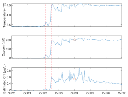
Intrusion Event Identified by the Bedford Basin Pod sensors. The start - end of the intrusion event is bordered by the red dashed line. The blue lines are from the sensor data and the red dot represents the discrete sample collected during the Wednesday BBTS sampling.
On October 22, 2018, oxygen, temperature, and chlorophyll spiked drastically within a few hours in the deepest part of the basin where the pod was moored. Smaller spikes in these parameters occurred on the days following the event, likely as the water continued mixing following this intrusion event. This capture of an intrusion event, and the speed (a few hours!) at which the water flushed into the basin could not have been captured by weekly or even daily traditional sampling methods from discrete water samples or a CTD. Previous weekly sampling by Dalhousie and BIO have identified intrusion events, however these changes in oxygen, salinity, and temperature are only picked up in the week-to-week differences, indicating that an intrusion event has taken place. While Bedford Basin scientists knew that this water was being replenished, the speed of these events could not quantified; that is until the Bedford Basin Pod was able to record this hourly data on the bottom of Bedford Basin.
Once the data from the first deployment underwent quality control and loose ends were tied up, the pod underwent a quick turn around with some modifications. The RBR ODO was replaced with an Aanderaa oxygen optode and the SUNA, which collects nitrate data, was fitted with a wiper to reduce fouling. Precise Design, a mechanical engineering group who made the original pod brackets, made the bracket modifications in no time at all and the CEOTR field technicians were able to deploy the pod for a second time just before the start of the spring bloom; in time to witness the basin come back to life after a cold winter.
For the second deployment of the pod, the CEOTR field crew decided to deploy the pod five meters closer to the bottom in order to gain a further understanding of the bottom waters, but not so close to get fouled by the sludge at the bottom of the Bedford Basin. The pod is currently deployed at 44˚41’52” N, 63˚38’28” W, slightly south of the last deployment to ensure that there is no instrument entanglement between the Bedford Basin Pod and the weekly BBTS sampling, and it will hopefully stay there until mid-May or early June.
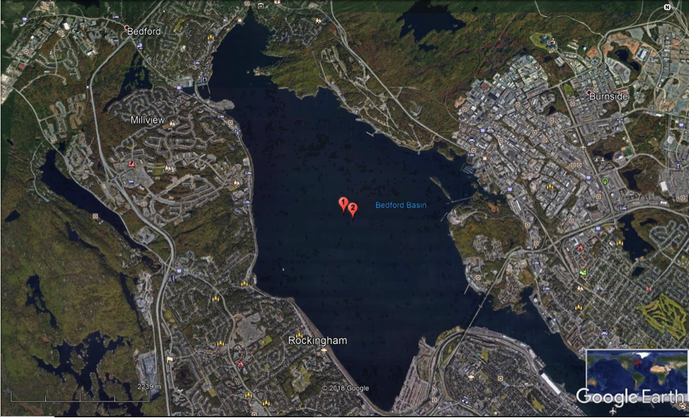
Location of Bedford Basin Pod deployment 1 and 2 within Bedford Basin
If the mooring does fail before the recovery date, there is an iridium GPS beacon included in the instrument suite that will send the CEOTR field group emails with the pod’s location every 5 minutes once the pod is floating at the surface. Fingers crossed that does not happen though, and that all the sensors, or “pod students”, collect valid data. Hopefully, the C+ pod students during the previous deployment will become A+ students for version 2.0. Following the collection of Bedford Basin Pod 2.0, the CEOTR Field Team is hoping to deploy 5 new pods (including oxygen optodes and CTDs, but a reduced instrument suite compared to versions 1.0 and 2.0) throughout Halifax Harbour, in an attempt to gain a further understanding of how these elusive intrusion events enter the Bedford Basin. It is clear that sending these “pod students” to work will help to further clarify the inner workings of Bedford Basin and the greater Halifax Harbour in the future.
Pod Deployment Preparation for Dummies...
or how to prepare the Bedford Basin Pod for 3-months at the bottom of Bedford Basin
How to Deploy the Bedford Basin Pod in Summer...
and in Winter...
Photo Gallery:


Recent News
- Recap of ASITA 2024 Conference
- ASITA 2024 Conference
- Happy World Ocean Day! + CMOS congress 2023 recap
- Upcoming presentations by CERC.OCEAN lab at the CMOS 57th congress
- UPDATED: List of Instrumentation and Analytical Services
- Field Report: Exploratory Study of nitrogen cycling at the Lagoon Lagos
- Marine Robots – Back in Action at OHMSETT
- Spotlight of the month: Adriana Reitano