 |
| David Stanley researched the Spencer's Island Company in the 19th century as a case study in Nova Scotian entrepreneurial success. (Nick Pearce Photo) |
As a kid growing up in Eastbourne, on the eastern shore of Wellington Harbour in New Zealand, David Stanley dreamt of a life of adventure on the sea. A sailor even before he hit the double digits, he loved the salty tales of swashbuckling adventure, buccaneer rogues and sailor skullduggery. Books like Treasure Island, Moby Dick and Mutiny on the Bounty fed his imagination.
“I gobbled it up, anything to do with the sea or adventure,” he said, from a rocky perch in Point Pleasant Park as the tall ships departed from Halifax Harbour under sunny skies on Monday afternoon.
When it came to learning more about maritime history, the New Zealander investigated different universities and settled on Dalhousie. And while one might think that his studies about the Age of Sail would have dissipated any romance remaining around the ships—he just graduated with his master’s in history in the spring—his face lights up like a nine-year-old boy's as he watched the sloops, clippers, schooners, square riggers and brigantines sail past, pushed forward by the breeze.
SEE MORE PHOTOS: Parade of Sail by Nick Pearce
“You can’t help but be amazed by the beauty of the vessels,” says Mr. Stanley, who lives on the water in Prospect Bay, N.S. and is now doing a second master’s at Dalhousie, this time in Environmental Studies. “The men who sailed them weren’t immune to the romance (of sailing) either but they were far more interested in the ships being sound.”
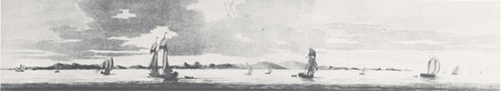
During the Age of Sail, Canada had the fourth largest merchant-shipping fleet in the world. Sail-powered wooden vessels were built in small Nova Scotia towns and villages on both sides of the Bay of Fundy—in villages like Advocate Harbour, Diligent River, Port Greville and Parrsboro on the one shore and Windsor, Maitland and Canning on the other shore.
One-hundred and fifty years ago, a tiny place like Spencer’s Island on the Parrsboro shore, for example, was a hotbed for shipbuilders and seafarers. Among the large output from its yards was the Amazon, built in 1861 (later to become famous as the ill-fated Mary Celeste), and the square-rigger Glooscap, which at 1,720 tons was the largest ship ever built in Spencer’s Island. It would have rivalled the giant Russian ship Kruzenshtern in its size.
“Ships like the Glooscap are today’s equivalent of oil tankers; they’d ship timber from Nova Scotia and New Brunswick, petroleum from the United States to Europe, then take on coal at Cardiff and take that to South Africa or South America. Then, they’d return with basic food stuffs,” explains Mr. Stanley, who researched the Spencer’s Island Company for his master’s thesis.
“It was a dirty job, a risky job. You could fall overboard in the night and you wouldn’t know how to swim. Your ship could hit an iceberg or hidden rocks along a coastline. Your ship might be carrying volatile cargo.”
Not to mention the back-breaking work, the unpredictable weather, the solitude and monotony and the lack of space and basic comforts aboard a ship. In fact, it all sounds rather grim.
“It was definitely an extremely dangerous occupation and the men who sailed were pretty hard.”
SEE STORY: 'Thinking with your hands:' Dal students create outdoor cinema in Spencer's Island
SEE PHOTOS: Architecture students evoke the Mary Celeste in a project in historic Spencer's Island. See photos.
Whereas tall ships today have GPS to pinpoint their position exactly on the globe, navigating a square rigger or a topsail schooner a century or two ago was a decidedly dangerous business. Coming into a harbour like Halifax’s, a captain would have relied on sea charts and local marine pilots to safely bring them dockside. “We tend to think that sailing on the open seas was the difficult part, but it was actually easier because there was nothing to run into,” explains Roger Marsters, who is researching marine cartography for his PhD in history and teaches the history of seafaring at Dalhousie and Saint Mary’s. “The tricky part was when you had to plumb the unseen channels of inshore waters.” It’s Mr. Marsters’ contention that the development of marine cartography was key to Great Britain becoming a naval and trading power in the 18th and 19th centuries. And, a Nova Scotian, J.F.W. Desbarres, played a crucial role by drafting detailed charts and views of North American coastlines that the British navy relied on. Originally from Switzerland, DesBarres came to North America as an engineer and a surveyor. After fighting in the French and Indian wars, he surveyed the coasts of Nova Scotia, Newfoundland and the St. Lawrence River regions. In 1774, he published the first great marine atlas with the rather poetic name the “Atlantic Neptune.” The four-volume Atlantic Neptune is now one of the treasures of Dalhousie University Archives, donated to the university by William Inglis Morse in 1933. |