News
» Go to news mainBCD student's climate change map receives accolades
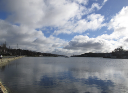
BCD student Florian Goetz’s story map, Viewing Halifax’s Northwest Arm With Extreme Water Levels, has been selected for the 2017 Esri Canada App of the Month. The work features a unique perspective which brings a realistic dimension to one of the biggest issues in our society today.
Climate change will result in more than changing temperatures as time goes on. One of these additional changes is global mean sea level. Scientists have predicted that by the year 2100 the global sea level could be more than a metre higher than the current global mean sea level.
Halifax, NS is expected to have a larger change in sea level than the global average. Water levels can also get much higher in the event of a storm and from local geographic conditions. By 2100, these conditions could increase Halifax’s water levels to higher than three metres.
Now, you could read about how high these water levels could reach, but have you ever wondered what these extreme water levels would look like?
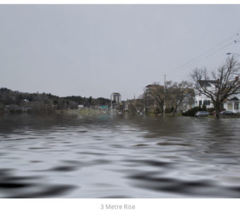
Click through the story map to learn about what is contributing to these extreme water levels, and see what Halifax’s Northwest Arm would look like with extreme water levels.
The map was featured in the Esri Canada Blog for the month of September. This StoryMap is a part of Florian Goetz’s Thesis Project. For more information on his project, click here.
Recent News
- Faculty of Architecture and Planning creates forum for discussing housing strategies for the future
- The Loaded Ladle providing food security for Sexton Campus students
- D'Arcy Jones' exhibition and talk brings community together
- From assistant professor to associate professor with tenure.
- Spring 2023 Convocation Address
- Dalhousie architecture students recognized in CASA Student Work Showcase
- Alumni engagement and student development in the Big Apple
- The School of Planning celebrates World Earth Day